DELTA Explores On-Location Photoscanning
As part of our new DELTA Explores series, we’re sharing how we research, test and explore the latest in immersive technology and its role in teaching and learning — how we Think before we Do. Immersive Media Developer Stephen Waddell shares a few 3D models captured through photoscanning at William B. Umstead State Park.
The New Media Development (NMD) team at DELTA works with a wide range of cutting edge technologies and in the hopes of staying on top of all of the rapid growth in the world of immersive media, we sometimes get the chance to work on investigating new processes and technologies. Recently we worked on a project that was intended to continue our investigation of augmented reality and photogrammetry for classroom use, and as part of that, we partnered with NC State faculty member Karl Wegmann to explore the potential of photogrammetry for capturing objects and spaces that could be useful in a distance learning environment.
During this project, I and several other members of DELTA here at NC State got the opportunity to go out on location at William B. Umstead State Park to photo-scan a few interesting subjects. From there we would go on to experiment with using the resulting assets in classroom-oriented learning environments.
The three subjects you’ll see here can all be found on location in Umstead but with new immersive technologies, we can also find them on the web or, with the help of AR, in your living room!
Rockstack at Umstead Park
This first model was captured in the river near Betty’s Mill, it just seemed like a fun subject and a good test of the scanning pipeline.
Man-Made Dam at Umstead Park
This model shows a section of a man-made dam found on the bank of the same river, structures like these date back before any record we have of the area.
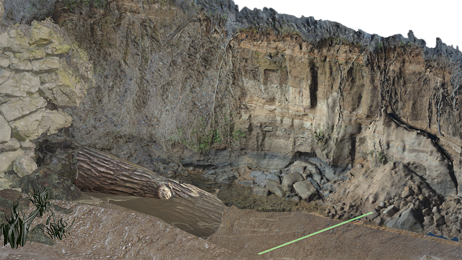
Soil Exposure at Umstead Park
The soil exposure was the star of our photo-capture outing, the stratigraphy that is so clearly visible on this bank of the river is used to help demonstrate the construction of a chronological soil record and was a key subject in a geology-focused AR experience we’ve been working on.
These are just a few examples of the results you can get working with photo-scanning and we’ll be continuing to refine our process. I want to include thanks for Matthew Castro who was also on-site and worked on the processing for many of the 3d objects scanned at Umstead as well as Michael Castro, Derek DeStefano, and Rhett Hissam for helping with the capture process.